![header=[Marker Text] body=[Since Indian days this was a major Youghiogeny River crossing place. In 1754 Washington's Virginians camped here. Braddock's army marched through here. The National Road bridged the river at this point in 1818. ] sign](kora/files/1/10/1-A-F5-139-ExplorePAHistory-a0a4r1-a_450.gif)
Mouse over for marker text
Name:
Great Crossings
Region:
Laurel Highlands/Southern Alleghenies
County:
Somerset
Marker Location:
US 40 at Youghiogheny River
Dedication Date:
October 24, 1947
Behind the Marker
An American traveler arrived at the "great crossings of the Youghogeny [sic] River" on September 1, 1810 and noted in his diary that the "fording [was] very bad." In early national America there were few obstacles more daunting to travelers than a river. It was difficult enough to journey over steep mountains, or slog through mud, but crossing a river meant facing a series of obstacles such as rocks and unknown depths that could often end in overturned wagons, ruined supplies, and death by drowning.
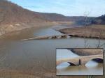
Great Crossings, while still a difficult area to navigate, was manageable enough for most experienced tradesmen or settlers looking to head west into the Ohio River Valley. The journey at Great Crossings became easier, however, when the federal government decided to construct the National Road. Forty feet high and 30 feet wide, it was built between 1815 and 1818. When it was opened on July 4, 1818, the bridge spanned 375 feet and boasted three stone arches made of locally quarried sandstone. The opening of the National Road Bridge over the Youghiogheny River was a grand affair with President James Monroe and several cabinet officers in attendance.
During the early 1940s, the U.S. Army Corps of Engineers destroyed the bridge by flooding the region as part of a river control project which created the Youghiogheny River Lake.
Great Crossings, while still a difficult area to navigate, was manageable enough for most experienced tradesmen or settlers looking to head west into the Ohio River Valley. The journey at Great Crossings became easier, however, when the federal government decided to construct the
During the early 1940s, the U.S. Army Corps of Engineers destroyed the bridge by flooding the region as part of a river control project which created the Youghiogheny River Lake.
Beyond the Marker


